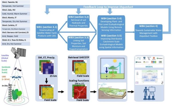
An integrative information aqueduct (iAqueduct) is proposed to close the gaps between global satellite observation of water cycle and local needs of information for sustainable management of water resources. In the past decades, various satellite missions have been developed to monitor the global water cycle, in particular the variables related to precipitation, evapotranspiration and soil moisture, often at (tens of) kilometre scales of spatial resolution. Whilst these data are highly effective to characterise water cycle variation on regional to global scale, they are not suitable for sustainable management of water resource, which always needs more detailed information on local (e.g. in terms of information provided by an in-situ sensor, e.g. a TDR for soil moisture or a piezometer for groundwater level) and field scale. To effectively exploit existing knowledge at the regional to global scale we thus need to answer the following questions: How to downscale the global water cycle products to local scale? How to convert the coarse resolution data into fine scale water information at the management scale for water, vegetation and soil processes? And how to use such fine-scale water information to improve the management of soil and water resources? The envisioned iAqueduct aims to accomplish these goals combining EC/ESA Copernicus satellite data (with intermediate resolution) with high resolution Unmanned Aerial System (UAS) and in-situ observations to develop scaling functions for soil properties and soil moisture and evapotranspiration at meter scales. iAqueduct will integrate the various components from the global water cycle observation to local soil and water states in an open-source water information system and test and demonstrate their utility on pan-European scale at a set of carefully selected research sites for sustainable management of water resources. iAqueduct complements the actions developed under the European Strategy Forum for Research Infrastructures (ESFRI) by coordinating a set of European research groups and sites allowing the scaling up to pan-European level under the aegis of the COST action Harmonization of UAS techniques for agricultural and natural ecosystems monitoring(HARMONIOUS) in which participate 70 institutions from 32 countries.

Research Group: Zhongbo (Bob) Su (ZS); Yijian Zeng (YZ); Brigitta Szabó (BS); Mészáros János (MJ); Salvatore Manfreda (SM); Eyal Ben-Dor (EBD, through Nicolas); Nicolas Franco (NF), Carolina Allocca (CA); Paolo Nasta (PN); Nunzio Romano (NR).
DELIVERABLES:
- Han, Q., Zeng, Y., Zhang, L., Cira, C.-I., Prikaziuk, E., Duan, T., Wang, C., Szabó, B., Manfreda, S., Zhuang, R., and Su, B.: Ensemble of optimised machine learning algorithms for predicting surface soil moisture content at a global scale, Geoscientific Model Development, 16, 5825–5845, https://doi.org/10.5194/gmd-16-5825-2023, 2023. [pdf]
- Francos, N.; Romano, N.; Nasta, P.; Zeng, Y.; Szabó, B.; Manfreda, S.; Ciraolo, G.; Mészáros, J.; Zhuang, R.; Su, B.; et al. Mapping Water Infiltration Rate Using Ground and UAV Hyperspectral Data: a Case Study of Alento, Italy. Remote Sens. 2021, 13, 2606. https://doi.org/10.3390/rs13132606
- Paridad P., Dal Sasso S.F., Pizarro A., Mita L., Fiorentino M., Margiotta M.R., Faridani F., Farid A., Manfreda, S., Estimation of soil moisture from UAS platforms using RGB and thermal imaging sensors in arid and semi-arid regions. ACTA Horticulture, 1335, 339-348, 2022.
- Paruta, A., P. Nasta, G. Ciraolo, F. Capodici, S. Manfreda, N. Romano, E. Bendor, Y. Zeng, A. Maltese, S. F. Dal Sasso and R. Zhuang, A geostatistical approach to map near-surface soil moisture through hyper-spatial resolution thermal inertia, IEEE Transactions on Geoscience and Remote Sensing, (doi: 10.1109/TGRS.2020.3019200) 2020.
- Zhang, L., Y. Zeng, R. Zhuang, B. Szabó, S. Manfreda, Q. Han, Z. Su, In Situ Observation-Constrained Global Surface Soil Moisture Using Random Forest Model. Remote Sens., 13, 4893, (doi: 10.3390/rs13234893), 2021.
- Zhuang, R.; Y. Zeng; S. Manfreda; Z. Su, Quantifying Long-term Land Surface and Root Zone Soil Moisture over Tibetan Plateau, Remote Sensing,12, 509, (doi: 10.3390/rs12030509) 2020.
- Su, Z., Zeng, Y., Romano, N., Manfreda, S., Francés, F., Dor, E.B., Szabó, B., Vico, G.; Nasta, P., Zhuang, R., Francos, N., Mészáros, J., Sasso, S.F.D., Bassiouni, M., Zhang, L., Rwasoka, D.T., Retsios, B., Yu, L., Blatchford, M.L., Mannaerts, C., An Integrative Information Aqueduct to Close the Gaps between Satellite Observation of Water Cycle and Local Sustainable Management of Water Resources. Water, 12, 1495, 2020. [pdf]
- Zhuang, R., S. Manfreda, Y. Zeng, Z. Su, E. Ben Dor and G. P. Petropoulos, Soil moisture monitoring using unmanned aerial system, in Unmanned Aerial Systems for Monitoring Soil, Vegetation, and Riverine Environments edited by S. Manfreda and E. Ben Dor, Elsevier, 2023.
- Zhuang, R., Manfreda, S., Zeng, Y., Zhang, L., Szabó, B., Su, Z., Random Forest Downscaling of Soil Moisture with a Comprehensive Optimization Approach, IEEE Transactions on Geoscience and Remote Sensing, under review, 2023.
- Dal Sasso, S.F., A. Pizarro, M. Fiorentino, MR Margiotta, B Onorati, S. Manfreda, Assessing the Performance of Single and Multi-Criteria Calibration Approaches for Hydrological Modelling: A Comparative Analysis Comparing single and multi-criteria calibration approaches for hydrological modelling, Hydrological Sciences Journal, (Under Review) 2023.


