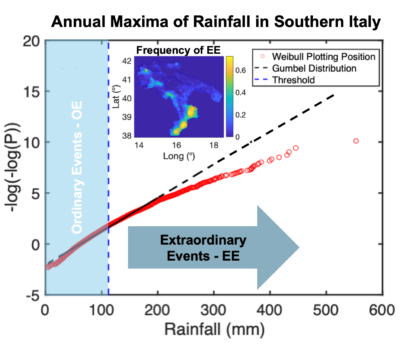
Extraordinary events are rarely observable in a single rainfall gauge, and this make extremely challenging the correct prediction of their arrivals. However, it may be possible to develop a more robust approach by employing a space–time modelling scheme that is able to capture the spatial dynamics of such phenomena. Therefore, a space–time Poisson model of rainfall cells with circular shape and random depth has been exploited for the first time to interpret the behaviour of this family of extraordinary events. This category of events that may be connected to larger meteorological phenomena not necessarily connected with local heterogeneity of the landscape. Following the identification of the observed extraordinary event across southern Italy, six zones with significantly different dynamics in terms of the frequency of such extremes were identified. Subsequently, a simple mathematical representation was adopted to calibrate the model parameters, leading to an estimate of regional probability distributions defined on the space–time occurrences of extraordinary events over homogeneous zones. The approach allows to overcome the limitations posed by point observations allowed the definition of a probability distribution that pertains to an entire area rather than just a point. The obtained quantiles of rainfall estimated seems to align well with the upper bound of the probability distribution of the annual maxima observed over the areas of interests.

How to cite: Manfreda, S., The space-time representation of extraordinary rainfall events, Ecohydrology (doi: 10.1002/eco.2742), 2024.
