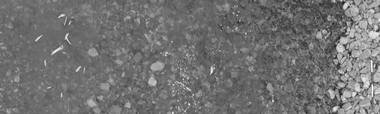
River flow monitoring is essential for many hydraulic and hydrologic applications related to water resource management and flood forecasting. Currently, unmanned aerial systems (UASs) combined with image velocimetry techniques provide a significant low-cost alternative for hydraulic monitoring, allowing the estimation of river stream flows and surface flow velocities based on video acquisitions. The accuracy of these methods tends to be sensitive to several factors, such as the presence of floating materials (transiting onto the stream surface), challenging environmental conditions, and the choice of a proper experimental setting. In most real-world cases, the seeding density is not constant during the acquisition period, so it is not unusual for the patterns generated by tracers to have non-uniform distribution. As a consequence, these patterns are not easily identifiable and are thus not trackable, especially during floods. We aimed to quantify the accuracy of particle tracking velocimetry (PTV) and large-scale particle image velocimetry (LSPIV) techniques under different hydrological and seeding conditions using footage acquired by UASs. With this aim, three metrics were adopted to explore the relationship between seeding density, tracer characteristics, and their spatial distribution in image velocimetry accuracy. The results demonstrate that prior knowledge of seeding characteristics in the field can help with the use of these techniques, providing a priori evaluation of the quality of the frame sequence for post-processing.
Keywords: river monitoring; image velocimetry; LSPIV; PTV; UAS; surface flow velocity; seeding density
How to cite: Dal Sasso, S.F.; Pizarro, A.; Manfreda, S., Metrics for the Quantification of Seeding Characteristics to Enhance Image Velocimetry Performance in Rivers. Remote Sens. 2020, 12, 1789. [pdf]
