The next Generally Assembly entitled Remote Sensing of the Environment using Unmanned Aerial Systems (UAS) of the Harmonious Cost Action will be on live streaming https://auth.gr/video/29478
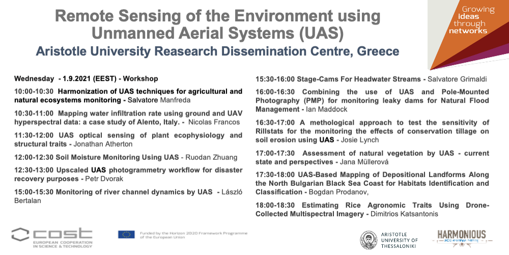
Program
9:00-9:30 Registration and welcome
9:30- 10:00 Welcome from local organization
10:00-10:30 Harmonization of UAS techniques for agricultural and natural ecosystems monitoring.
Salvatore Manfreda
10:30-11:00 Mapping water infiltration rate using ground and UAV hyperspectral data: a case study of Alento, Italy.
Nicolas Francos, N. Romano, P. Nasta, Y. Zeng, B. Szabó, S. Manfreda, G. Ciarolo, J. Mészáros, R. Zhuang, B. Su, E. Ben-Dor
11:00 -11:30 Coffee Break
11:30-12:00 UAS optical sensing of plant ecophysiology and structural traits
Jonathan Atherton
12:00-12:30 Soil Moisture Monitoring Using UAS.
Ruodan Zhuang, S. Manfreda, Y. Zeng, Z. Su, E. Ben Dor, G. P. Petropoulos
12:30-13:00 Upscaled UAV photogrammetry workflow for disaster recovery purposes.
Petr Dvorak, I. Jebacek, M. Cervenka, T. Hajek, R. Popela, J. Juracka
13:00-13:20 – Discussion
13:20-15:00 Lunch break
15:00-15:30 Monitoring of river channel dynamics by UAS.
László Bertalan, A. Eltner, I. Maddock, A. Pizarro
15:30-16:00 Stage-Cams For Headwater Streams.
Salvatore Grimaldi, S. Noto, F. Tauro
16:00-16:30 Combining the use of Uncrewed Aerial Systems (UAS) and Pole-Mounted Photography (PMP) for monitoring leaky dams for Natural Flood Management.
Ian Maddock, J. Lynch, J. Atkins
16:30 – 17:00: A methological approach to test the sensitivity of Rillstats for the monitoring the effects of conservation tillage on soil erosion using Uncrewed Aerial Vehicles (UAVs).
Josie Lynch
17:00-17:30 Assessment of natural vegetation by UAS – current state and perspectives.
Jana Müllerová and members of the WG2
17:30-18:00 UAS-Based Mapping of Depositional Landforms Along the North Bulgarian Black Sea Coast for Habitats Identification and Classification.
Bogdan Prodanov, I. Kotsev, R. Bekova, T. Lambev, L. Dimitrov
18:00-18:30 Estimating Rice Agronomic Traits Using Drone-Collected Multispectral Imagery
Dimitrios Katsantonis, Dimitrios Stavrakoudis, Argyrios Kalaitzidis
Topic: Harmonious Workshop – September 2021
Join Zoom Meeting
https://authgr.zoom.us/j/94267194820?pwd=bjlTLzFKTzFSMTJiSFdXUlE3N3JFQT09
Meeting ID: 942 6719 4820
Passcode: 028670
