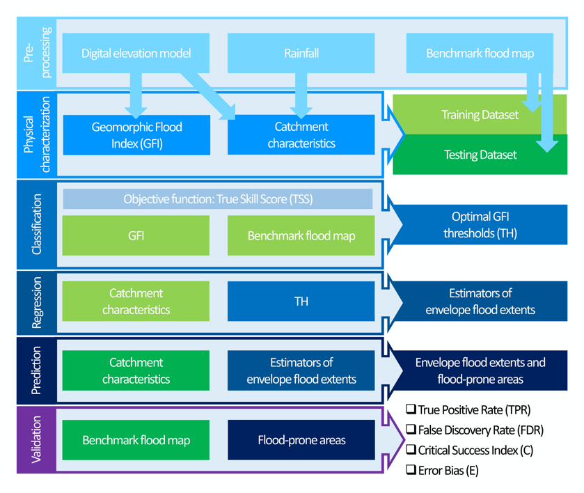
Seeding Distribution Index (SDI)
The code for the estimation of the Seeding Distribution Index (#SDI) is now available online on OSF. The SDI can help in the identification of the optimal frame window for…
Università degli Studi di Napoli Federico II - DICEA
The code for the estimation of the Seeding Distribution Index (#SDI) is now available online on OSF. The SDI can help in the identification of the optimal frame window for…
Thermal inertia has been applied to map soil water content exploiting remote sensing data in the short and long wave regions of the electromagnetic spectrum. Over the last years, optical…
A topographic index (flood descriptor) that combines the scaling of bankfull depth with morphology was shown to describe the tendency of an area to be flooded. However, this approach depends…
Rainfall-triggered shallow landslide events have caused losses of human lives and millions of euros in damage to property in all parts of the world. The need to prevent such hazards…
Since the turn of the 21st century, image-based velocimetry techniques have become an increasingly popular approach for determining open-channel flow in a range of hydrological settings across Europe and beyond.…
Large-scale flood risk assessment is essential in supporting national and global policies, emergency operations and land-use management. The present study proposes a cost-efficient method for the large-scale mapping of direct…
Dear Colleagues, Recent technological advances in both remote sensing and soil mapping approaches and progress in establishing harmonized soil profile datasets have opened up the potential to derive global gridded…
River flow monitoring is essential for many hydraulic and hydrologic applications related to water resource management and flood forecasting. Currently, unmanned aerial systems (UASs) combined with image velocimetry techniques provide…
The past decades have seen rapid advancements in space-based monitoring of essential water cycle variables, providing products related to precipitation, evapotranspiration, and soil moisture, often at tens of kilometer scales.…
This is the questionnaire developed by HARMONIOUS aimed at identifying the most urgent and important challenges drone-based science will probably face in the near future. All UAS users are encouraged…
River monitoring is of particular interest for our society that is facing increasing complexity in water management. Emerging technologies have contributed to opening new avenues for improving our monitoring capabilities,…
With the increasing role that unmanned aerial systems (UAS) are playing in data collection for environmental studies, two key challenges relate to harmonizing and providing standardized guidance for data collection,…
River monitoring is a critical issue for hydrological modelling that strongly relies on the use of Flow Rating Curves (FRCs). In most of the cases, FRCs are approximated by least-squares…
La Società Idrologica Italiana (SII) insieme alle Università della Campania stanno organizzando le Giornate dell’Idrologia 2020 che si terranno a Napoli il 16-18 luglio 2020. Save the date!
It is crucial to monitor the dynamics of soil moisture over the Tibetan Plateau, while considering its important role in understanding the land-atmosphere interactions and their influences on climate systems…